Recent public Naga discussions (argument) about the primary or secondary stakeholders in the Naga political issue appear to be based on the current naming and jurisdiction nomenclature. According to all the reliable sources, Naga-inhabited areas include the state of Nagaland, parts of Arunachal Pradesh, Assam, and Manipur, all of which are administered by India, and parts of Sagaing Division and Kachin State, both of which are administered by Myanmar. “The Naga races are not confined to the Naga Hills; they also inhibit much of Lakhimpur, the Cachar Hills, Manipur, and parts of Burma,” according to Commonwealth Relations Office files under part D of SEA 39/5/1.
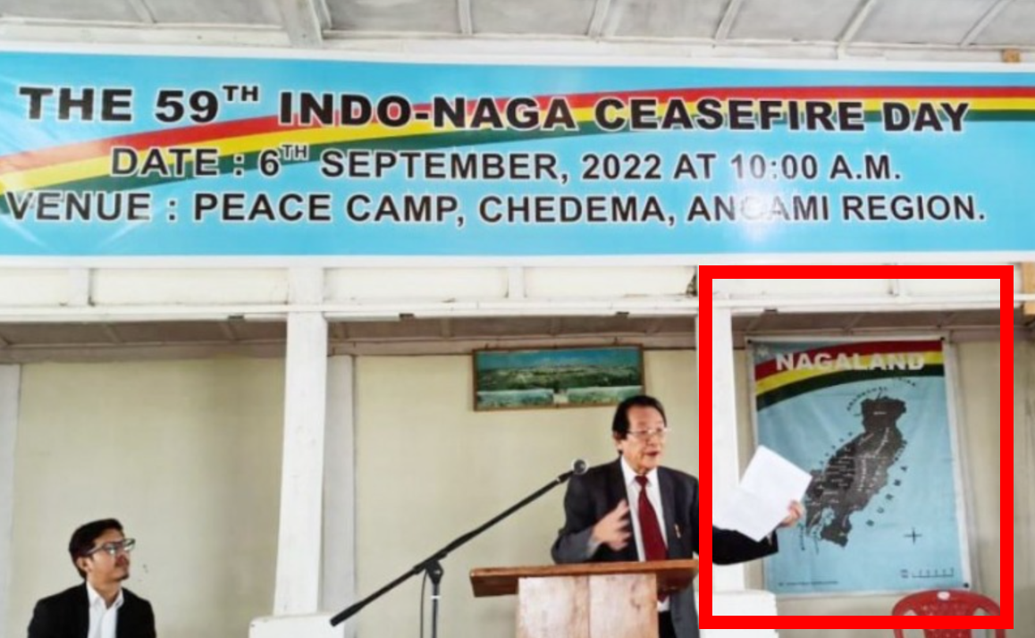
What drew my attention to the Federal Government of Nagaland (FGN)/Naga National Council (NNC) observation of the 59th Indo-Naga Ceasefire Day at Peace Camp, Chedema, Nagaland on September 6, 2022, was not the event banner, but the “Nagaland” map (See the featured image above. FGN/NNC observes 59th Indo-Naga Ceasefire Day at Chedema (Original image) / Photo: India Today NE / Reworked Square: ICNA) in the background.
The Naga ancestral homeland map is frequently projected in various media and reports, including think-tank platform (See the image below: The title and image are available on the MP-IDSA website) as a “Greater Nagalim/Greater Nagaland” or proposed Nagalim map of the National Socialist Council of Nagalim (NSCN), possibly out of ignorance or to further create a greater conundrum to the Naga political issue. However, it would be fair to say that the map of Nagaland visible in the background of the recent September 6, 2022, FGN/NNC event serves as a great reminder to the Naga people and the outside world of what Naga nationalist organizations, particularly the NNC, mean by “Nagaland” in terms of Naga territorial jurisdiction.

It comes at a time when there is much confusion and counterargument about how to read the current position or situation, including the territorial jurisdiction of the Naga people, by both Nagas and non-Nagas. As a result, it will be necessary to review the existing records as well as the approaches that have been adopted by the Naga people and organizations.
Naga Territorial Jurisdiction and A Surviving Map:
Nagaland Territory, On Record – According to the NNC
According to Article 1 of “The Yehzabo of Nagaland,” adopted by the Federal Government of Nagaland (Provisional Yezhabo of 1962 as well as the amended/approved Yehzabo of July 25, 1968), “The territory of Nagaland shall comprise all the territories inhabited by the indigenous Naga Tribes…”
Naga Homeland Map, On Record – The Naga Hoho Logo
The Naga Hoho logo clearly depicts the undivided Naga homeland map (See the image below: The logo image captured from Naga Hoho’s press statement letter). It is the Apex Naga Body that works across all Naga inhabited areas, regardless of imposed boundaries, to create a well-represented socio-political body for the Naga people, to integrate all divided Naga areas, and to defend traditional Naga territories, cultures, and people.
![]()
Combating the Divide and Rule Strategy: The NSCN’s Nagalim Approach
The inclusion of a portion of the Naga ancestral homeland into the Indian union in 1963 to suppress the FGN/NNC sparked division among the Naga people. Following further disagreements within the NNC, the National Socialist Council of Nagaland (NSCN) was formed on January 31, 1980. The NSCN’s “Nagalim” approach can be seen as a political strategy to counter the “Divide and Rule” strategy, to distinguish the Indian-created state of Nagaland from Nagaland – the ancestral Naga homeland. From that perspective, it is not incorrect to say that the NSCN began using the term “Nagalim” instead of “Nagaland” in 1999, referring to the entire Naga areas under India and Myanmar. The word “Lim” is derived from the Ao Naga language (dialect) “Limah,” which means “Land.”
Conclusion:
Regardless of the level of the argument and counterargument on the reading of the position or situation regarding the Naga inhabited area map or map of Nagaland, Naga Land, Nagalim, to Naga nationalist organizations like the Naga National Council (NNC) and National Socialist Council of Nagalim (NSCN), Nagaland or Nagalim refers to the entire Naga-inhibited territories under India and Myanmar’s administrative control. As a result, the question of “Greater” or “Smaller” Land or Lim does not arise. Whatever the ongoing Naga public debate (argument) about primary or secondary stakeholders in the Naga political issue today, the participation of all the Naga villages in the Naga National Movement, the map of Naga territory used by the NNC, NSCN, and the Naga Hoho logo says it all.
Author’s Disclosure Statement: Augustine R. is an independent researcher on the India-Naga-Myanmar political issue, as well as on broader global security and strategic issues. He is also the Editor-in-Chief and Publisher of the International Council of Naga Affairs (ICNA) web publication platform and does not work for, consult for, own shares in, or receive funding from any company or organization that would benefit from this article/opinion.
Featured Image: FGN/NNC observes 59th Indo-Naga Ceasefire Day at Chedema / Photo: India Today NE / Reworked Square: The International Council of Naga Affairs (ICNA)
ICNA reserves all rights to the content submitted. The author’s views are their own and do not necessarily reflect those of nagaaffairs.org